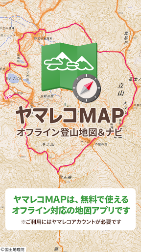
Yamareko is a map application that can be used as a GPS for mountaineering and outdoor activities.
It is the only app that can support the activities necessary for mountaineering, from making a mountaineering plan to submitting a mountaineering notification, checking a map during mountaineering, and creating records after mountaineering.
It also supports Wear OS smart watches!
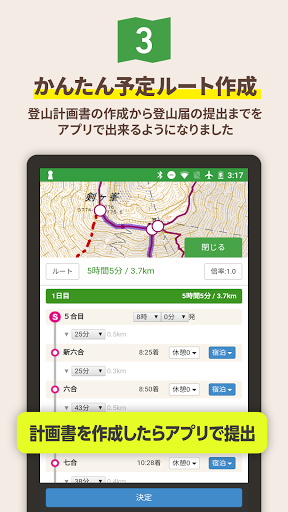
[Before mountain climbing] You can easily create a planned mountain climbing plan in advance and submit a mountain climbing notification to each prefecture via the "Compass" system of the Japan Mountain Guide Association.
You can download the submitted mountain climbing notification map and route information before climbing.
[Climbing] Since
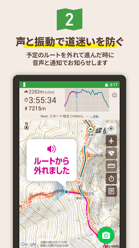
the map is downloaded in advance, you can check your current location with GPS even in the mountains where the radio waves of mobile phones do not reach.
If you also enter the planned route, you can display the arrival time of the mountaintop or the trailhead based on the current walking pace. You can also easily leave photos and videos while climbing.
In addition, by linking with the "Ima Coco" app and website, you can safely and in real time tell your family and friends your current location only while climbing a mountain using the "Yamareco" app, so you can rest assured!
[After climbing] After
climbing, you can contact the "Compass" system from the app to let your family know that you have successfully climbed.
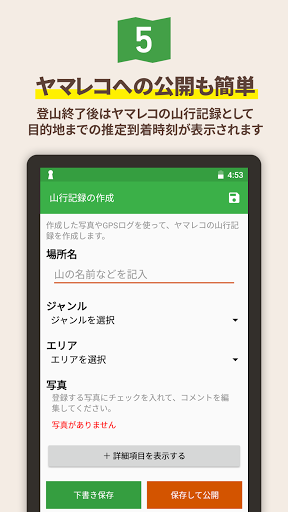
You can easily publish information on the Internet by leaving the photos you have taken and GPS logs as "mountain line records" on the Yamareco website.
In addition, since the information remains on the server, it can be used as a backup when the smartphone is broken.
【Features】
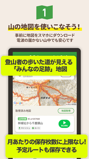
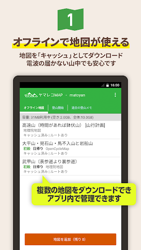
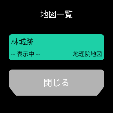
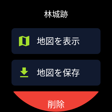
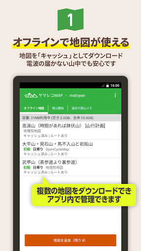
1) Map can be used offline
You can download and use the map of the Geographical Survey Institute as a "cash" for the domestic market.
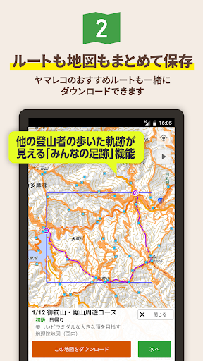
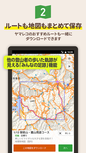
In addition, Yamareko's "Footprints of Everyone" is also displayed, so you can see at a glance where everyone is actually walking (where the mountain trail is).
Of course, the place name data registered in Yamareco is also included, so you can check minor mountains and passes that are not on the map.
2) Submit mountain climbing notifications online You
can create a mountain climbing plan with the app and submit it to the compass as it is, in cooperation with the "Compass" system operated by the Japan Mountain Guide Association.
In each prefecture with which the Japan Mountain Guide Association is affiliated, submitting a plan to the compass will be treated as if you had submitted a mountain climbing notification.
Since the mountain climbing notification submitted online at the time of distress rescue is used, it is more secure than submitting it to an unmanned mountain climbing post on paper, and it is possible to respond quickly in the event of an emergency.
3) You can download the route and map as a set You can download
not only the pre-prepared area map but also the route and map created in the mountain climbing plan.
You can also download routes and maps from other people's mountain line records, GPX files, etc.
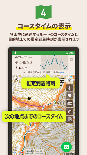
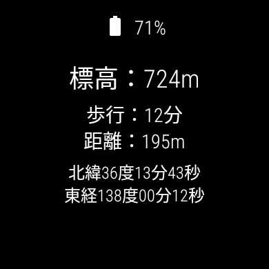
4) Know the arrival time!
The downloaded map shows the standard course time, so you can easily imagine when and where you will arrive while climbing.
Also, if you enter the route you plan to walk, it will show you when and when you plan to arrive at each point (mountain peak, branch, climbing entrance, etc.) that you pass based on the pace you are walking.
I think it can be used as a criterion for when to turn back in the mountains so that you can go down the mountain by sunset.
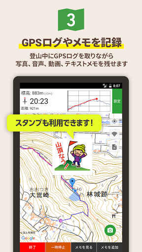
5) You can leave GPS logs and memos while climbing!
When you start climbing, you can leave notes in text in addition to GPS logs and photos.
You can leave the excitement of standing on the mountaintop on the spot!
6) You can share your current location with your family!
If you take a GPS log, you will be able to periodically leave your current location in Yamareco and check your current location with Yamareco's "Ima Coco" function.
By accessing "Ima Coco" on your family's computer or smartphone, your family can check your current location at any time.
■ Now here
https://www.yamareco.com/labo/locviewer/
Even if you don't need it, you can turn off the function from the settings.
Please use it if necessary.
7) You can easily keep a record of mountain trips!
You can easily create a mountain line record using the photos and GPS logs you created while climbing!
When you finish climbing, you can automatically make a draft, so you can make a record immediately when the train is open on your way home.
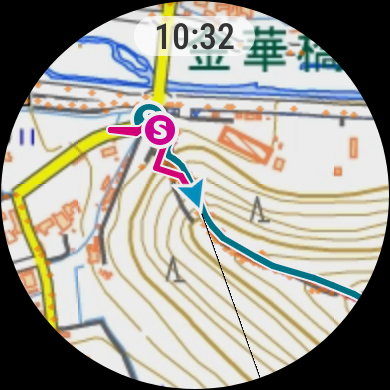
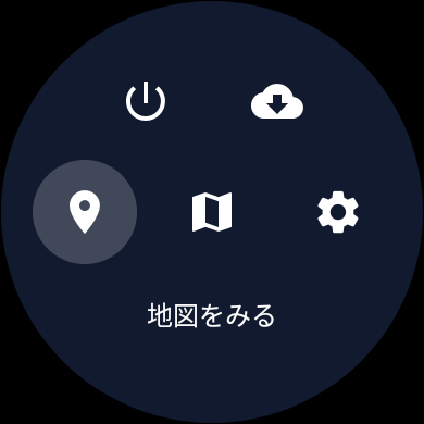
8) Can also be used with smart watches!
With a smartwatch equipped with Wear OS by Google, you can easily check the map at hand. In addition, you will be aware of warnings when you deviate from the planned route, so you can enjoy climbing more safely!
* Applies to smart watches with Wear OS 2.0 or later.
We have confirmed the operation with PRO TREK Smart WSD-F30 / WSD-F21HR / WSD-F20, Suunto 7, and Fossil Sport, but it can also be used with other Wear OS 2 compatible smart watches.
[Countermeasures when GPS log is interrupted] -Open the
Settings app and check that the location information mode of your current location information is set to "High accuracy".
・ If you are using a power saving / power saving app, try excluding the Yamareco app from power saving.
-Try setting not to optimize the battery in the Android setting application "Battery"-> "Battery optimization".
[Countermeasures when the current location cannot be obtained / GPS log cannot be obtained from the beginning]
-Check that the sky is widely visible so that signals from GPS satellites can be received.
-Check that your current location is available with an app that can acquire the status of GPS satellites.
・ If you are using an MVNO carrier such as a cheap SIM that cannot use A-GPS, it may take about 10 minutes to obtain the first location information.
-Open the Settings app and check that the location information mode of your current location information is set to "High accuracy".
-Turn off location services and then turn it on again.
・ Try restarting your smartphone.
Please read the information on the following page as well.
Especially for HUAWEI smartphones, GPS logs are interrupted, so settings are required.
https://sites.google.com/site/yamarecomapandroid/help/keep_gps_logging
[Maximum number of map downloads] The maximum number of map downloads
is 1 for guests and 2 for login (free of charge). There is no limit to the number of downloads per month.
You can download the map again for free by deleting the cache you no longer need after each climb.
If you are subscribed to Yamareco's premium plan (paid), you can download without limit until the capacity of your smartphone allows.
* The "Footprints of Everyone" function displays the trajectory of the actual walk, but it may include roads that cannot be passed depending on the variation route and season, abandoned roads, etc., and guarantees that the information is always accurate. Not.
When making a mountain climbing plan, please be sure to collect the latest information through the Yamareco website and local related organizations before climbing the mountain.
* For the prefectures with which "Compass" is affiliated, please check the Compass website below.
https://www.mt-compass.com/
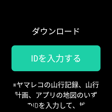
* To use the smartphone application, you need to register as a user of Yamareco.
http://www.yamareco.com/
■ Android version usage guide
https://www.yamareco.com/guide/guide_android/
■ Wear OS version usage guide
https://www.yamareco.com/guide/guide_wearos / /
version 5.7.2a
· Keep binaries for older models
Version 5.6.0
-Fixed a bug that the app crashes on the share image generation screen under certain conditions
Version 5.5.5
・ Added a function to display readings on the place name page
Version 5.5.1 optimized for Android 11 ・
Fixed a bug that the installation status of other apps could not be confirmed
Version 5.3.9
· Galaxy Watch4 correspondence
as a measure of when the gesture to draw from the top of the screen to the bottom is in the menu of the device, modified to menu of the app comes out even in the upper tap of the screen
Version 5.3.8
・ Added a function to change the font size of the place name icon on the map
・ Fixed a bug that users are duplicated in the follow list etc.
・ Updated various libraries
Version 5.3.6
・Bug fixes that the app crashes during the storage migration process under certain conditions
Version 5.2.6
-Added the function to make a pawn sound before starting a speech-
Fixed other problems, etc.
version 4.9.5
-Renewed the UI of the map list screen-
Updated various libraries-
Version 4.9.4
-Fixed a bug that some course time data download failed-
Version 4.9.1
・ Fixed a bug that the app crashes under certain conditions
Version 4.8.8
-Fixed a bug that the size setting was not reflected when registering a photo of Yamayuki record.
Version 4.8.7
・Addition of subscription ( monthly , yearly )
Version 4.8.5
-Added the function to reflect the location information of the mountain climbing memo (photo) on the website when creating the mountain climbing memo from the mountain climbing memo. -
Fixed the problem that the date is not displayed in the record list for the group mountain climbing record.
-Fixed a bug that failed to register photos of mountain climbing memos that match specific conditions-Fixed a bug that the
walking pace was not displayed under specific conditions
version 4.8.3
If the application is killed in the middle of editing the-climbing record, adds the ability to restore the data in the editing
Version 4.8.0
-Fixed a bug that failed to upload photos on Android 10 or later-
Updated various libraries-
Version 4.7.8
・ Fixed bugs in the questionnaire function ・
Updated various libraries
Version 4.7.5
・ Update of various libraries
Version 4.7.3
・ Renewal of home screen The
Version 4.7.0
-Added the function to update information on the numerical display screen of Wear OS at any time-
Fixed other bugs-
Updated various libraries-
Version 4.6.9
・ Added a function to display an information icon on the plan creation screen
Version 4.6.7
-Fixed a bug that the deviation warning is not given when the entire planned route is almost flat
-Other bug fixes
Version 4.6.6
-Corrected the name of the app read out at the time of deviation warning to the current application name
Version 4.5.9
・ Updated the premium plan subscription page
・Updated various libraries
version 4.5 of various libraries . 6.
Fixed a bug that the app rarely crashes when calculating calories.
Version 4.5.3
-Changed the supported OS to Android 5.0 or later-
Updated
-Added the function to display the grading of the mountain on the plan creation screen Version 4.5.1
- Added the function of "Mountain Climbing Accident Map"
Version 4.5.0
Version 4.4.9
・ Improved GPS log end judgment on the clock side ・
Fixed a bug that the scheduled route on the smartphone side does not appear under certain conditions
・ Fixed other bugs
Version 4.3.4
・ Update of various libraries
Version 4.3.1
-Added a function to select and enter the equipment column of the plan from the equipment list
-Equipped Added a function to edit the list-Added
a function to save the equipment column of the plan as an equipment list
Version 4.2.9
-Fixed a bug that failed to download elevation data when planning a route
Version 4.2.8
-The route input function of the plan. Renewal
-Abolished "draw route" function
Version 4.2.5
-Added the function to skip the memo screen after pressing the camera button-
Fixed broken menu links-Clear
Version 4.2.3
-Update of various libraries
Version 4.2.0
-Fixed a bug that the route before editing was displayed even after editing the route of mountain line record
Version 4.1.9
-Usage guide, URL change for inquiries-Modified the
Version 4.0.8
-Fixed to automatically move to the tab that was open at the last time when the app was started- Removed the
unintended emoji code conversion function
Version 4.0.0
・ Renamed the app
Version 3.4.9
・ Added a search function to each user's mountain line record list
・ Added
a place name page・Added a function to move to a place name page from a place name link at the bottom of a mountain line record or plan
version 3.4.7
・ Check if it goes off the screen on the photo selection registration screen of the mountain line record or diary Fixed a bug that
the photo is
version 3.4.4
・ Supports offline display of plans
・ Update of various libraries
・
Please check the update history before other bug fixes from the following
https://sites.google.com/site/yamarecomapandroid/history
Version 3.4.2
・ Change the direction display icon during mountain climbing to "Arrow & Line" and add a function that can be changed in the settings
・ Update various libraries
・
Check the update history before other bug fixes from the following
https: / /sites.google.com/site/yamarecomapandroid/history
Version 3.4.1
-Added "All route map" to each user's page-
Fixed a bug that some Youtube preview images are not displayed-
Updated various libraries
-Other bug fixes
Please check the update history before
https://sites.google.com/site/yamarecomapandroid/history
Version 3.3.0
・ Add function to edit mountain records ・ Support overseas maps (OpenTopoMap)
Please check the previous update history from below
https://sites.google.com/site/yamarecomapandroid/history
Version 3.2.8
・ Add function to display your own mountain records
Please check the previous update history from below
https://sites.google.com/site/yamarecomapandroid/history
Version 3.2.3
· Tap the place name icon to fix the details · Added function to check access after icon tap such as climbing mouth
Please check the previous update history from the following
https://sites.google.com/site/yamarecomapandroid/history
Version 3.1.9
- Fixed a bug that the application drops rarely when opening the map screen while climbing stopped · Update various libraries
Please check the previous update history from the following
https://sites.google.com/site/yamarecomapandroid/history
Version 3.1.1
- Added a function to display a warning when notification is not permitted at the start of mountain climbing
Please confirm the previous update history from the following
https://sites.google.com/site/yamarecomapandroid/history
Version 2.8.7
- Added a function to display the estimated arrival time to the next point when there is a planned route · Added function to display list of estimated arrival times of each point
Please confirm the previous update history from the following
https://sites.google.com/site/yamarecomapandroid/history
Version 2.8.5
- Fix to make the route and track lines on the map easier to see (thicken and add outlines)
· Corrected the course time to make it easier to view (background added to bold)
· Small application size (App Bundle compatible)
Please confirm the previous update history from the following
https://sites.google.com/site/yamarecomapandroid/history
Version 2.8.0
- Fixed a bug that the application fell at a specific timing
Please confirm the previous update history from the following
https://sites.google.com/site/yamarecomapandroid/history
Version 2.7.4
- Fixed a bug that the GPS log would not stop when an application was forcibly dropped from Android under certain conditions
Please confirm the previous update history from the following
https://sites.google.com/site/yamarecomapandroid/history
Version 2.7.1
· Fixed bug that download stopped stopping when network was unstable when downloading map · Other bug fixes
Please confirm the previous update history from the following
https://sites.google.com/site/yamarecomapandroid/history
Version 2.6.7
- Fixed a bug that version 2.6.6 failed to download data after the end
Please confirm the previous update history from the following
https://sites.google.com/site/yamarecomapandroid/history
Version 2.6.3
· Added menu function · Added function to draw route on map download screen
Please confirm the previous update history from the following
https://sites.google.com/site/yamarecomapandroid/history
Version 2.6.2
· "View on 3D map" button added to plan detail screen
Please confirm the previous update history from the following
https://sites.google.com/site/yamarecomapandroid/history
Version 2.6.1
· Change the access button to an easy-to-understand position · Fixed a problem not going from 0% even if retrying once when failing to download the map
Please confirm the previous update history from the following
https://sites.google.com/site/yamarecomapandroid/history
Version 2.6.0
· Added function to check access to mountain plan and map preview page · Update various libraries
Please confirm the previous update history from the following
https://sites.google.com/site/yamarecomapandroid/history
Version 2.5.9
- Fixed a problem that submission is done more than once when hit compass submit button repeatedly
Please confirm the previous update history from the following
https://sites.google.com/site/yamarecomapandroid/history
Version 2.5.8 - Fixed a bug that the application will fall when trying to enter new compass emergency contacts · Change to input method that you can select year, month, and day separately from calendar input for date of birth · Corrected so that submitter information you entered can be reused · Other defect fixes Please confirm the previous update history from the following https://sites.google.com/site/yamarecomapandroid/history
Version 2.5.6 - Fixed photo size setting notation · Other defect fixes Please confirm the previous update history from the following https://sites.google.com/site/yamarecomapandroid/history
Version 2.5.5 · Added function to change members of the Yama line plan · Other defect fixes Please confirm the previous update history from the following https://sites.google.com/site/yamarecomapandroid/history
Version 2.5.3 · Fixed a bug that the application drops when opening the plan list on Android 4.4 or later terminal - Fixed a bug that garbage MAP application is displayed even when opening an unrelated file · In the case of a map created from the plan, the function to open the plan in the application is added · Other defect fixes Please confirm the previous update history from the following https://sites.google.com/site/yamarecomapandroid/history
Version 2.5.1 · Post notes, detailed graph display, climbing memo list, detailed screen design change · Other defect fixes Please confirm the previous update history from the following https://sites.google.com/site/yamarecomapandroid/history
Version 2.5.0 · Change the map display design during climbing and climbing · Added scale display function · Other defect fixes Please confirm the previous update history from the following https://sites.google.com/site/yamarecomapandroid/history
Version 2.4.3 - Fixed a bug that the application drops when enlarging the map when "everyone's foot after" of version 2.4.1 or earlier is downloaded Please confirm the previous update history from the following https://sites.google.com/site/yamarecomapandroid/history
Version 2.4.0 · Supports display of shadows · Added display cache function · Updating various other libraries Please confirm the previous update history from the following https://sites.google.com/site/yamarecomapandroid/history
Version 2.3.5 · Corresponds to the problem that some GPX files can not be read · Terminal function can be turned off even in terminals without electronic compass · Updating various other libraries Please confirm the previous update history from the following https://sites.google.com/site/yamarecomapandroid/history